OZCAR-RI OMERE Kamech catchment - France
DEIMS.ID
https://deims.org/c617f8c8-1b19-4683-8546-a3c23c39bc0b
ProTip! Use the DEIMS.ID to reference sites in papers, reports or anywhere else.
Basic Information
Site Name
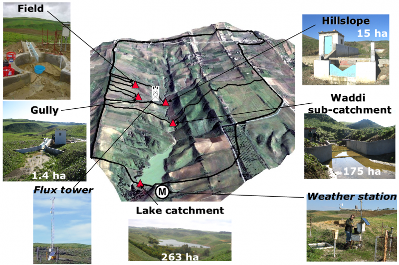
OZCAR-RI OMERE Kamech catchment
Short name
Kamech
Country
France
Web Address
Site Manager
Site Description
Last modified
2024-03-04 09:30:51
![]()
General Characteristics and Status
Site Status
Operational
Year Established
1994
Observed properties
Affiliation and Network Specific Information
Affiliation
ILTER✔This site is a verified "ILTER" member.
OZCAR RI✔This site is a verified "OZCAR RI" member.
LTER Europe✔This site is a verified "LTER Europe" member.
LTER France✔ (CZO_EU_FR_141)This site is a verified "LTER France" member.
Critical Zone Collaborative Network (CZ Net)✖The affiliation of this site with "Critical Zone Collaborative Network (CZ Net)" is not verified by the network on DEIMS-SDR.
Photos
Geographic
Centroid/Representative Coordinates
Latitude: 36.8714 Longitude: 10.8689
Size
ca. 263.00ha
Elevation (average)
130.00msl
Elevation (min)
90.00msl
Elevation (max)
190.00msl
Download