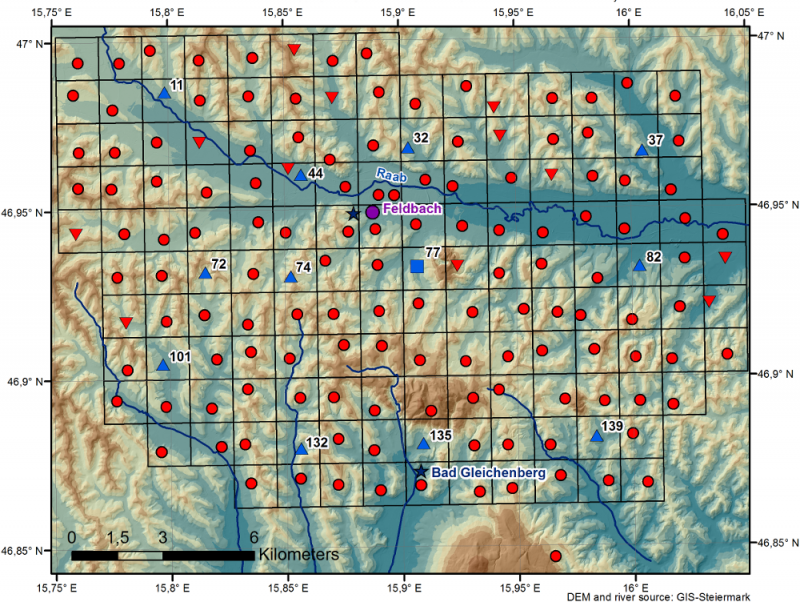
WegenerNet Feldbach Region - Austria

Basic Information
Site Name
WegenerNet Feldbach Region
Short name
WegenerNet FBR
Country
Austria
Funding Agency
Site Description
The WegenerNet climate station network Feldbach region is a pioneering weather and climate observation experiment at very high resolution located in Eastern Styria near the city of Feldbach in Southeast Austria, a region characteristic for experiencing a rich variety of weather and climate patterns. The network comprises 156 meteorological stations measuring temperature, precipitation, and other parameters, in a tightly spaced grid within an area of 23 km x 18 km centered near the city of Feldbach (46.93°N, 15.90°E). With its stations every about two square-km (area of about 300 square-km in total), and each station with 5-min time sampling, the network provides regular measurements since January 2007. As of 2010 a complementary meteorological-hydrological network of several stations was added in the mountainous upper Styrian region of National Park Gesaeuse as contribution to the LTER site Johnsbachtal (the "sister site" LTER_EU_AT_029_001 of this site LTER_EU_AT_029_002, both affiliated with the LTSER Platform Eisenwurzen). As part of the Johnsbachtal site, the WegenerNet Johnsbachtal consists of fourteen mountain-proof stations within a region-scale of about 10 km, ranging from valley altitudes below 700 m to mountain tops higher than 2100 m. The WegenerNet at both sites together provides strong value for both alpine foreland and mountain region studies.
Last modified
2023-07-24 11:07:56

CC-BY-NC Logo

General Characteristics and Status
Site Status
Operational
Year Established
2007
Observed properties
Affiliation and Network Specific Information
Affiliation
International Soil Moisture Monitoring Network (ISMN) (https://ismn.geo.tuwien.ac.at/en/networks/?id=WEGENERNET)The affiliation of this site with "International Soil Moisture Monitoring Network (ISMN)" is not verified by the network on DEIMS-SDR.
ILTERThis site is a verified "ILTER" member.
LTER EuropeThis site is a verified "LTER Europe" member.
LTER Austria (LTER_EU_AT_029_002)This site is a verified "LTER Austria" member.
Photos
WegenerNet FBR overview map
WegenerNet FBR impressions
Geographic
Elevation (average)
330.00msl
Elevation (min)
250.00msl
Elevation (max)
598.00msl
Download

Site information [.json]

Centroid/representative coordinates [.shp] [.kml]
Bounding Box [.shp] [.kml]
Boundaries [.shp] [.kml]