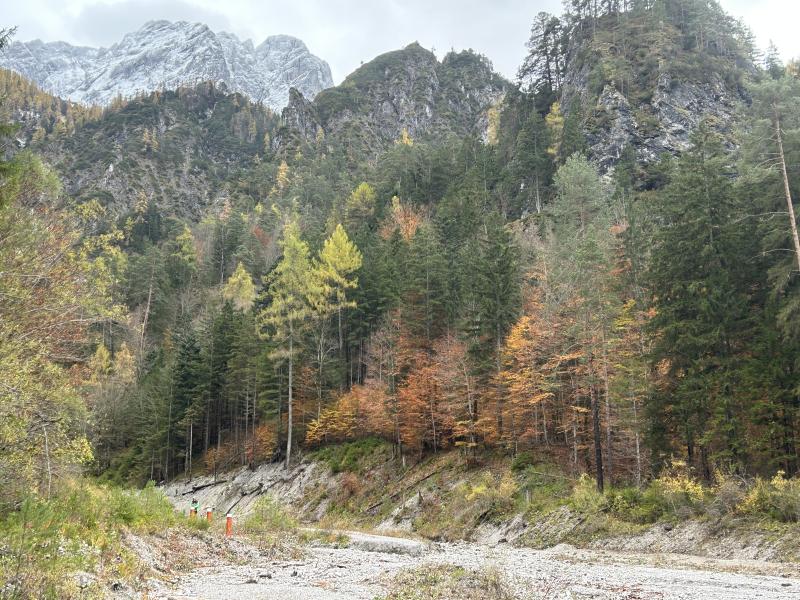
Gesäuse-Johnsbachtal - Austria

Basic Information
Site Name
Gesäuse-Johnsbachtal
Short name
Gesaeuse-Johnsbachtal
Country
Austria
Site Description
The Gesäuse Nationalpark and the Johnsbach valley belong to the Ennstal Alps, a part of the Northern Limestone Alps. They are situated in the province of Styria in the center of Austria. Together, they form the joint test site named Gesäuse-Johnsbachtal. This region is characterized by a mountainous landscape which is cut by the river “Enns”. In the north, it borders Eisenwurzen Nature Park and is only 6 km away from the Kalkalpen, a National Park in Upper Austria. In the south, the borders are the Eisenerzer Alps. The total area of the site is about 155 km². The terrain shows a great elevation range from 600-700 m in the Johnsbach valley to over 2300 m in the summit region of the Gesäuse, with Hochtor (2369 m) being the highest ...
Show more ...
Last modified
2025-01-07 11:01:56

CC-BY-NC Logo

General Characteristics and Status
Site Status
Operational
Year Established
2002
Observed properties
atmospheric parametersoil parameterecosystem parameterwater parameterenvironmental parameterairtemperatureatmosphericpressureglobalradiationirradianceprecipitationintensityreflectedglobalradiationirradiancerelativehumiditysnowdepthsnowwaterequivalentwinddirectionwindspeedsoilbasesaturationsoilbulkdensitysoilclassificationsoilorganiccarbonsoilparticlesizesoilpHsoiltemperaturesoiltexturefishabundanceforestcoverlandcovertypeleafareaindexspecieslistsnowcoversnowdepthwaterlevelwatertemperaturewatervelocitygroundsurfacetemperaturesnowdepth
Climate
JanFebMarAprMayJunJulAugSepOctNovDec mm 0 20 40 60 80 100 200 300-70 -40 -10 0 10 20 30 40 50 °C
Average Monthly Air TemperatureAverage Monthly Precipitation
Precipitation Sum:    1408 mm
Temperature Mean: 4.76 °C
No reference period has been provided
Affiliation and Network Specific Information
Affiliation
ILTERThis site is a verified "ILTER" member.
LTER EuropeThis site is a verified "LTER Europe" member.
GERIThis site is a verified "GERI" member.
LTER Austria (LTER_EU_AT_005)This site is a verified "LTER Austria" member.
Photos
Visitor center "Erlebniszentrum Weidendom", Enns river and Hochtor mountain range
Geographic
MarkerMarkerMarkerMarkerMarkerMarkerMarkerMarkerMarker
2 km
1 mi
Centroid/Representative Coordinates

Latitude: 47.527735344211 Longitude: 14.619570857209

Size
ca. 6546.00ha
Elevation (average)
1346.00msl
Elevation (min)
584.00msl
Elevation (max)
2367.00msl
Download

Site information [.json]

Centroid/representative coordinates [.shp] [.kml]
Bounding Box [.shp] [.kml]
Boundaries [.shp] [.kml]